


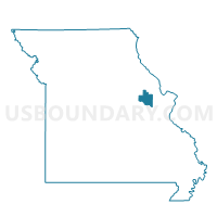
Hopewell Voting District, Warren County, Missouri
About
Outline

Summary
| Unique Area Identifier | 611530 |
| Name | Hopewell Voting District |
| County | Warren County |
| State | Missouri |
| Area (square miles) | 36.33 |
| Land Area (square miles) | 36.11 |
| Water Area (square miles) | 0.22 |
| % of Land Area | 99.39 |
| % of Water Area | 0.61 |
| Latitude of the Internal Point | 38.70453210 |
| Longtitude of the Internal Point | -91.13041950 |
Maps


Graphs
Select a template below for downloading or customizing gragh for Hopewell Voting District, Warren County, Missouri


Neighbors
Neighoring Voting District (by Name) Neighboring Voting District on the Map
- Concord Hill Voting District, Warren County, MO
- Dutzow Voting District, Warren County, MO
- Elkhorn South Voting District, Warren County, MO
- Holstein Voting District, Warren County, MO
- Innsbrook Voting District, Warren County, MO
- Macedonia Voting District, Warren County, MO
- Marthasville Voting District, Warren County, MO
- Smith Creek Voting District, Warren County, MO
- South Hickory Grove Voting District, Warren County, MO
Top 10 Neighboring County Subdivision (by Population) Neighboring County Subdivision on the Map
- Hickory Grove township, Warren County, MO (9,326)
- South Elkhorn township, Warren County, MO (7,249)
- Charrette township, Warren County, MO (5,579)
- Pinckney township, Warren County, MO (1,186)
Top 10 Neighboring Place (by Population) Neighboring Place on the Map
Top 10 Neighboring Unified School District (by Population) Neighboring Unified School District on the Map
- Washington School District, MO (31,485)
- Warren County R-III School District, MO (18,599)
- Wright City R-II School District, MO (10,768)
Top 10 Neighboring State Legislative District Lower Chamber (by Population) Neighboring State Legislative District Lower Chamber on the Map
Top 10 Neighboring State Legislative District Upper Chamber (by Population) Neighboring State Legislative District Upper Chamber on the Map
Top 10 Neighboring 111th Congressional District (by Population) Neighboring 111th Congressional District on the Map
Top 10 Neighboring Census Tract (by Population) Neighboring Census Tract on the Map
- Census Tract 8201.02, Warren County, MO (8,412)
- Census Tract 8202.02, Warren County, MO (7,508)
- Census Tract 8202.01, Warren County, MO (2,216)